HECTARE-MAP
ON SIZE A4 PAPER
MAPS IN THREE SHAPES
On this page are maps of a hectare in three different shapes, a rectangle, a square and a hexagon. They are also placed in an outine version for printing.
THE HECTARE AND UNIFIED HECTARE
The first image shows a map of a hectare in hexagonal shape. It contains both the size of a hectare as well as a slightly larger hectare which includes part of the surrounding infrastructure. The latter is called the unified hectare and is specially designed for the Earth Hectare Grid.
MAP ON A4 SIZE SHEET OF PAPER
The map is designed in scale of the Metric system on an A4 size sheet of paper. But a number of measurement units from the imperial measuring system have also been added. It is mainly in yards as these are closest to the meter unit. So for now one can also work with this map for the imperial system. (when time permits a map for the imperial system will be designed as well).
MATCHED TOGETHER
On top of that have the numbers of both measurement systems been matched together. This was done with the intention that they both contain as many whole numbers as possible and are therefore fairly easy to work with. More explanation will follow after the Map.

THE LIGHT GREEN WIDE STRIP
The light green colored wide strip surrounding the hectare includes the hectare parcel and is the boundary of the hectare as well. This is designed as the ‘Green Living Fence’. It consists largely of a canopy of trees, and might even be wider going inward, depending on ones own unique lay out.
THE SMALL GREEN STRIP
The small green strip is part of the slightly larger Unified Hectare. This is the extended hectare field flowing over into the green strip. It is designed to become part of the surrounding infrastructure of the hectare. It may consist of a grass verge (free to maintain by grazing livestock such as sheep or horses), or be covered with flowering plants for the bees, or just be part of the accessible road.
CIRCUM CIRCLE RADIUS: 64M/70YD
The most important to remember is the CCR, short for ‘Circum Circle Radius’ of 64 Meters or 70 Yards. This is the length of all six sides of the hexagonal hectare, and also the length of the distances from all six corners to the center. With a cord of this distance (or even half of it) one can draw circles and thus create the anchor points to construct the hexagonal shape of the hectare.
APOTHEM: 55.5M/60.70YD
The ‘A’ on the map stands for the ‘Apothem’ of 55.50 Meters or 60.70 Yards! The Apothem is in the middle of all sides. With this measure the road can be outlined by drawing one more circle, but yet at a shorter length compared to the CCR.
With this, one can measure an equal distance of the road width all around the hectare. One might even start constructing the hectare with the apothem, for the double number is the total width of the hectare including the surrounding road.
ARE YOU THE PIONEER?
It’ll be helpful if you have studied this map just a little bit, and also know how to construct a hexagonal hectare. If you haven’t seen it yet, here are the guidelines how to do so!
CO-CREATION
Then you will know how to apply these numbers of distances to design this hectare lay-out on the ground in real size! Although it might look complex a bit, once the measures are right it is really simple to construct, also on real scale!
ARE YOU THE FUTURE ANCESTOR?
Just keep in mind that in fact it is an extra challenge to have to design the shape of a hectare and to construct the lay-out in the field. You might be the first future ancestor of your descendants who actually created their family domain. So you’re the pioneer! Or one step further, you might even be the founder of an entire village of family domains.
This is because it is possible to design an entire village of family-domains with the lay-out of this one hectare. It can simply be done by placing more of the same shapes next to each other. This way all future families of the village can co-create the village together. An idea for which the time has come?

THE UNIFIED HECTARE OUTLINE
The maps are also designed in outline and on a transparent background and can be printed on paper or transparent film. (but not for professional press printing). Right click on the image and save it to your computer. The advantage of the outline design is it won’t cost you all the ink of your printer cartridges. And one might prefer to use other colors as well when drawing on paper.
USED AS AN OVERLAY
It can be used as an overlay on a map of a landscape, or for instance on google maps. Make sure the scale is the same!
The sheet of paper can also be placed on window glass, so the light shines through. This way one can draw the lines over and over again on new sheets of paper and make sketches on them as much as one prefers!
DESIGN ON A3 SIZE OR LARGER
There is also an option to have it enlarged and print it in 4 parts, thus on four A4 sheets of paper. By taping them together one can design the hectare on an even larger scale! Those can be put on the floor as well, and be placed together with similar designs of your possible future neighbours!
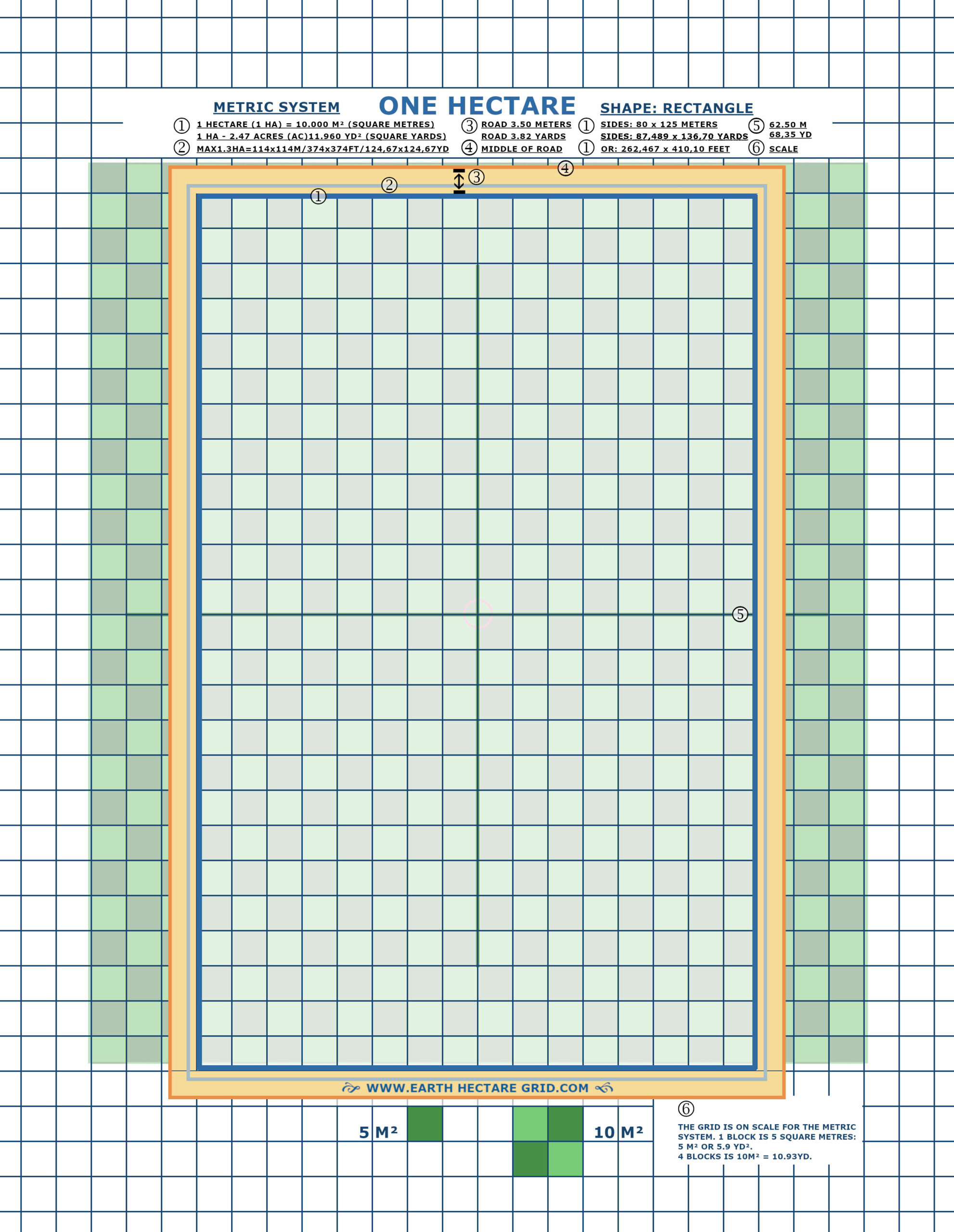
ONE HECTARE OR 2.4 ACRES
The next map is of a hectare in rectangle shape. This is the most common shape seen nowadays in agricultural landscape. So this might be the shape that will be most applied. The road has the same width of 3.50 Meters or 3.82 Yards as the hexagonal hectare.
ADJUSTING THE SHAPE
Other shapes or irregular forms of the hectare can also be drawn with the help of this map. For instance when a particular shape needs to fit in a certain area of a landscape. One can do this by simply drawing the blocks of square meters or square yards in other positions.
However, the amount of blocks need to stay the same, for the total surface area has to maintain the hectare range. So with every new square meter or yard that is drawn, another will have to be erased!

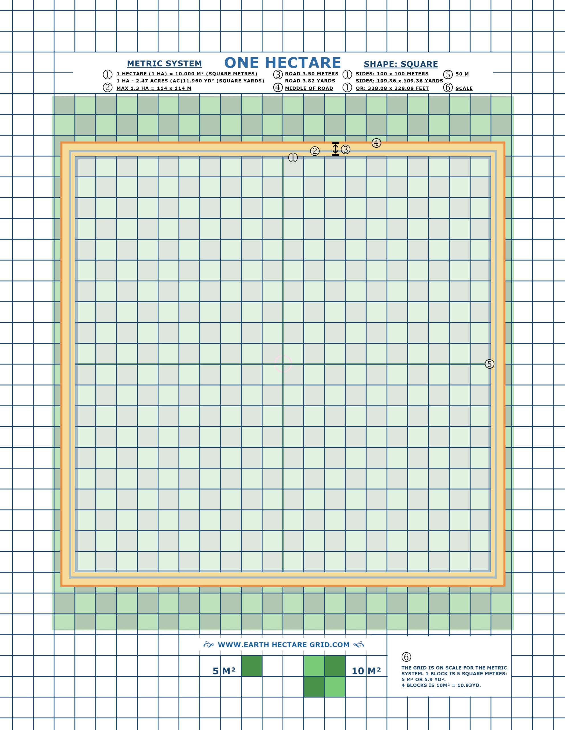
ONE HECTARE OR 2.4 ACRES
The third map is of a hectare in the shape of a square. It might also serve as an example for the dimensions of a hectare, as many of us aren’t familiar with it! This is even more so for those who work with the Imperial system of measurement. So this one contains the basic principles and measures.
DIMENSIONS AND COÖRDINATES
Are you as good in math as the founder of this website? Than you might want to use some extra tools for your calculations. So please calculate again for a double check!
A very useful tool for creating the hexagonal shape is
the Omni Calculator:
CALCULATING A HEXAGON
The calculator works with various units of measurement (defaults to cm). For each distance or calculation one has to set the desired unit first.
Next you type the number you want to calculate in front of those measuring values.
For instance: ‘1’.
So 1 ac (acre), or 1 ha (hectare).
Or 1 yd2 (square yard) or 1m2 (square meter), etcetera.
Another online calculator that works great.
*******