CO-CREATION
IT STARTS WITH DESIRE
CO-CREATION
THE SHAPE
THE CIRCLE
THE CORNERS
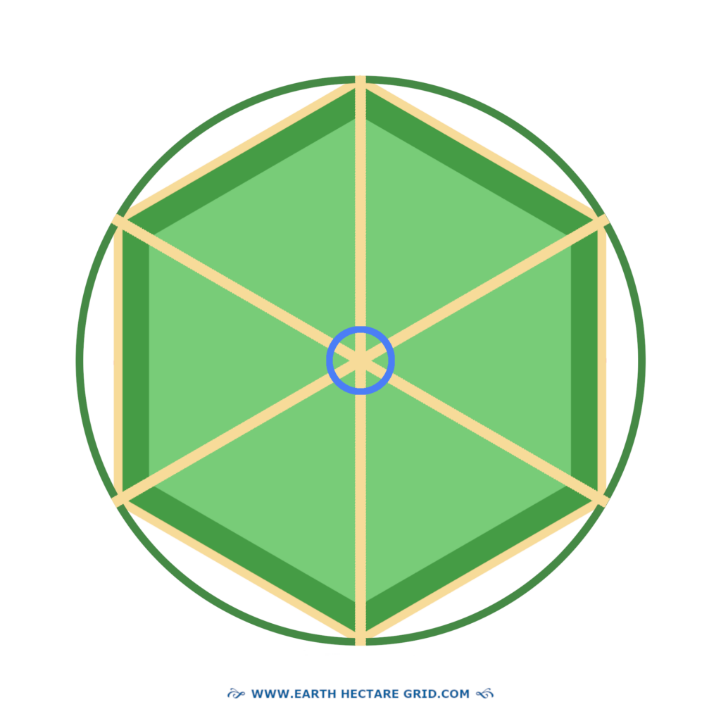
MAP OF A HECTARE
A map of a hectare, also in it’s equivalent measure of 2.4 acres, can be a very useful tool!
One can make various considerations for the layout and creation of the hectare in full size on the actual land! Thats why three different maps are presented here in the shapes of a rectangle, square and hexagon.
One can adjust these designs as one wishes, as long as the proportions of a hectare or 2.4 acres stay the same. So it can be also oblong or completely irregular in shape, but the hectare size must stay intact.
The hexagonal shape needs a bit of study in order to construct it. A helpful tool for this is the ‘Flower of Life’ design.
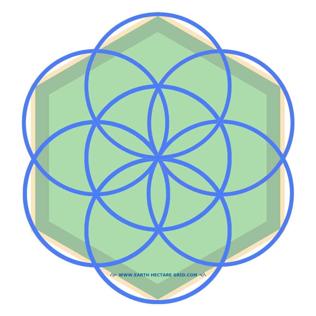
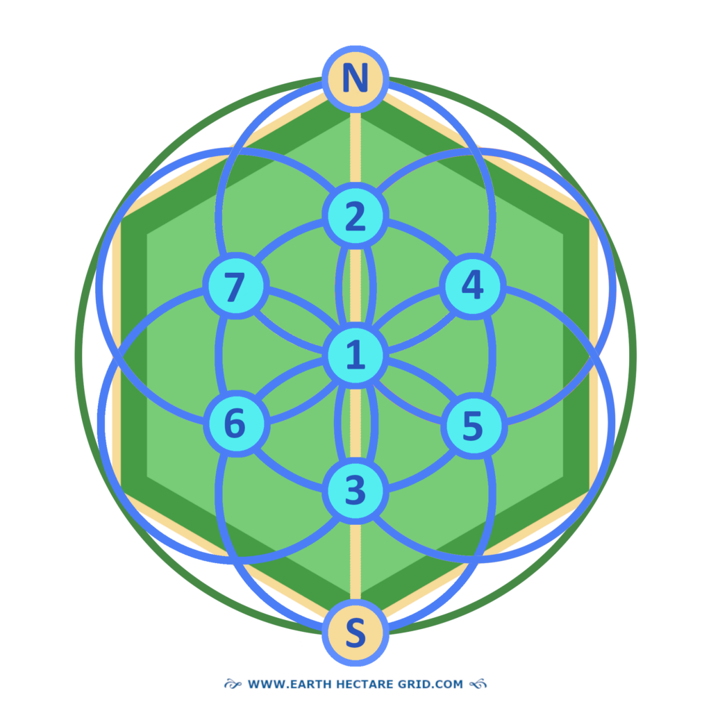
We’ll start with this design as it has many advantages! The hexagonal shape, here in green color with a small yellow outline, has six equal sides. It fits perfectly in a ‘Flower of Life’ construction, those are the circles in blue.
FLOWER OF LIFE
So how is this created? The ‘Flower of Life’ is a basic lay out of seven circles with one of its circles in the middle. They systematically overlap each other.

BASIC LAY OUT
The first circle onde draws is the circle in the middle. After this, the second circle is drawn from the northern point of the first circle.
This creates other points where the two circles overlap. From there the other circles can be drawn! And indeed, now it looks like a flower with petals!
SEED OF LIFE
Sometimes the basic Flower of Life formation with its 7 circles, is also called ‘Seed of Life’. This is because the basic shape can be duplicated and thus a Flower of Life pattern emerges.
In that sense has the flower of life become a building block.
DUPLICATING THE FLOWER
The flower as a basic shape or as a ‘seed of life’ can be duplicated by shifting the whole by a semicircle. It can be moved in all directions.
Below to the left one can see the Flower of Life in yellow. It is embedded as a Seed of Life in the middle with its repeated shape surrounding it, thus creating a pattern.

So to the right one sees the single pattern which repeats itself indefinitely.
So this is where the flower of life in its primary form of 7 circles, is as such the ‘building block’ for constructing the pattern.
SYMBOL OF REGENERATION
And one can view this also symbolically! Because a flower once fertilised contains seeds.
So that’s another reason why the Flower of Life as a building block is called Seed of Life.
It has also become a symbol for the regeneration of life.
THREE STEPS OF ASSESMENT
There are three steps of preparation prior to designing the hectare.
HOME IS WHERE?
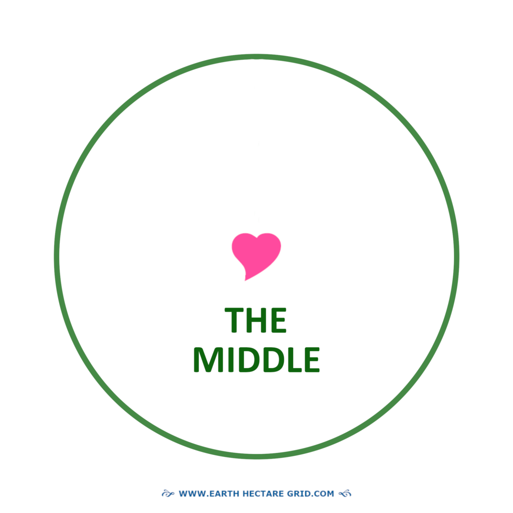
The first step is assessing what will be the middle of your hectare. This is because from the middle the entire hectare is drawn. And due to this being a process of assessment, we’ll place a heart in the middle for now.
It must feel good, right!?
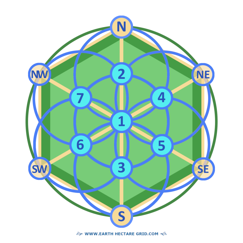
Then of course one also needs to figure where the outer boundaries of the hectare will be located. For this, one needs to know only one dimension of the hexagonal hectare. This is the ‘The Long Diagonal’.
The third step is finding North!
THE THREE LONG DIAGONALS
The hexagonal hectare has six equal sides and six equal outer vertices. In between these vertices or outer corners, three diagonals can be drawn towards their opposite corners.
These three long diagonals overlap each other in the middle.
THE NORTH-SOUTH DIAGONAL
The hexagonal hectare has a ‘standing’ position. As a result, one of the three long diagonals automatically forms a vertical line between North And South.

The length of this Long Diagonal is
140 yards or 128 metres.
DETERMINING NORTH
But where exactly is North? A compass can show us the approximate direction!

Its freely moving pointer aligns with the magnetic north of our planet. This magnetic field is located around the center of our planet Earth’s North Pole.
MAGNETIC NORTH
It is known however that magnetic north can fluctuate by hundreds of kilometers. So what if hectares are built worldwide with the tip pointing to the fluctuating magnetic North?
Nothing much really. There will be only slightly tilting deviations of the standing hexagonal shape of the hectares.
However, every individual family domain can adapt the green vegetative landscaping of the hectare to the true north, if one wishes.
GEOGRAPHIC NORTH
Also, the magnetic north is not the geographic North, which is based on the supposed rotational axis of our planet Earth. But there are also other methods of finding true North which we will get into later!
CIRCUM CIRCLE RADIUS
So we’ve assessed the size of the hectare on the actual land. We’ve also determined the middle and North. Now we can create the surrounding circle of the hectare!
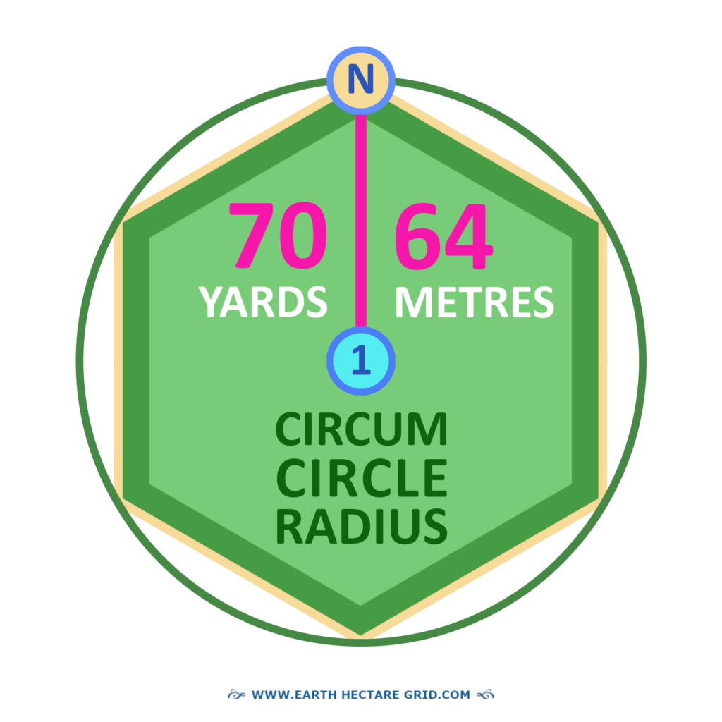
But first we have replaced the heart in the middle with the number 1. This is because it’s the place from where both the outer and inner circles are drawn. It is also the turning point for the ‘Circum Circle Radius’. (CCR).
The CCR is a line with half the length of the Long Diagonal. This line starts from the middle and ends at the outer vertices of the hectare.
And it’s important to know:
The Circum Circle Radius has the same size as the six sides of the hexagon!
70 YARDS OR 64 METRES
When a hexagon has the exact size of a hectare, the CCR is 67.85 Yards and 62.04 Metres. These aren’t easy numbers to work with.
While searching for an answer it appeared that by rounding the numbers up, the dimensions could be simply equalized, both for the metrical- and imperial measurement systems.
These are the values of a Circum Circle Radius of 70 yards and 64 meters, which are almost equally in length (with a tiny difference of 1 inch), and are both round numbers.
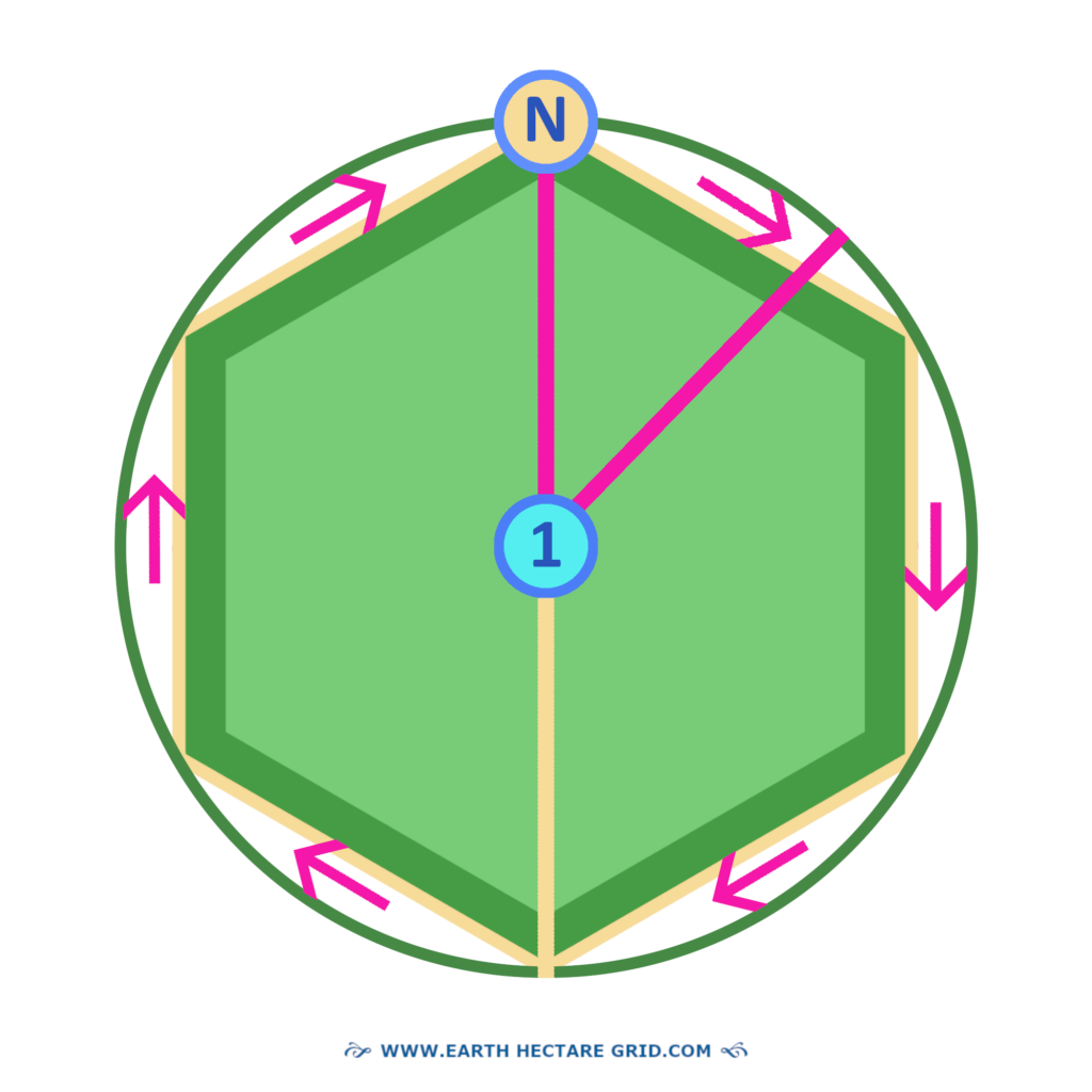
HOW TO DRAW THE CIRCLE?
And now the question might be: How are we going to draw the circle? As seen below, it can be done by turning the CCR around, just like the hands of a clock.
WHAT DO YOU NEED FOR THIS?
What tools do we need to draw it? And what does it cost to perform accurate measuring of a hectare on its real scale?
To start with this question, initially all one needs is a cord or rope with the length of 70 yards or 64 metres. Thats it.
Remember this is your Circum Circle Radius! Additionally one might need a few simple items such as a stick, and a tent peg.
THEN, WHAT DOES IT COST?
Well, with a bit of luck nothing! This is when you already have these items at hand, or stored somewhere in your house in that messy drawer you haven’t sorted out yet.
THE MESSY DRAWER:
“Here it is darling. This is all you need. I’ve kept is safe for you for all those years. All materials are still in a good condition. Succes, and remember, I love you”.

“Geesh, thank you drawer!” A small ball of jute rope of 100 metres or 100 yards (300 feet long).
THE MIDDLE CIRCLE
Now we can make a choice to either draw the vast circle surrounding the hectare or the smaller circle in the middle of the hectare. This is the first circle of the Flower of Life formation!
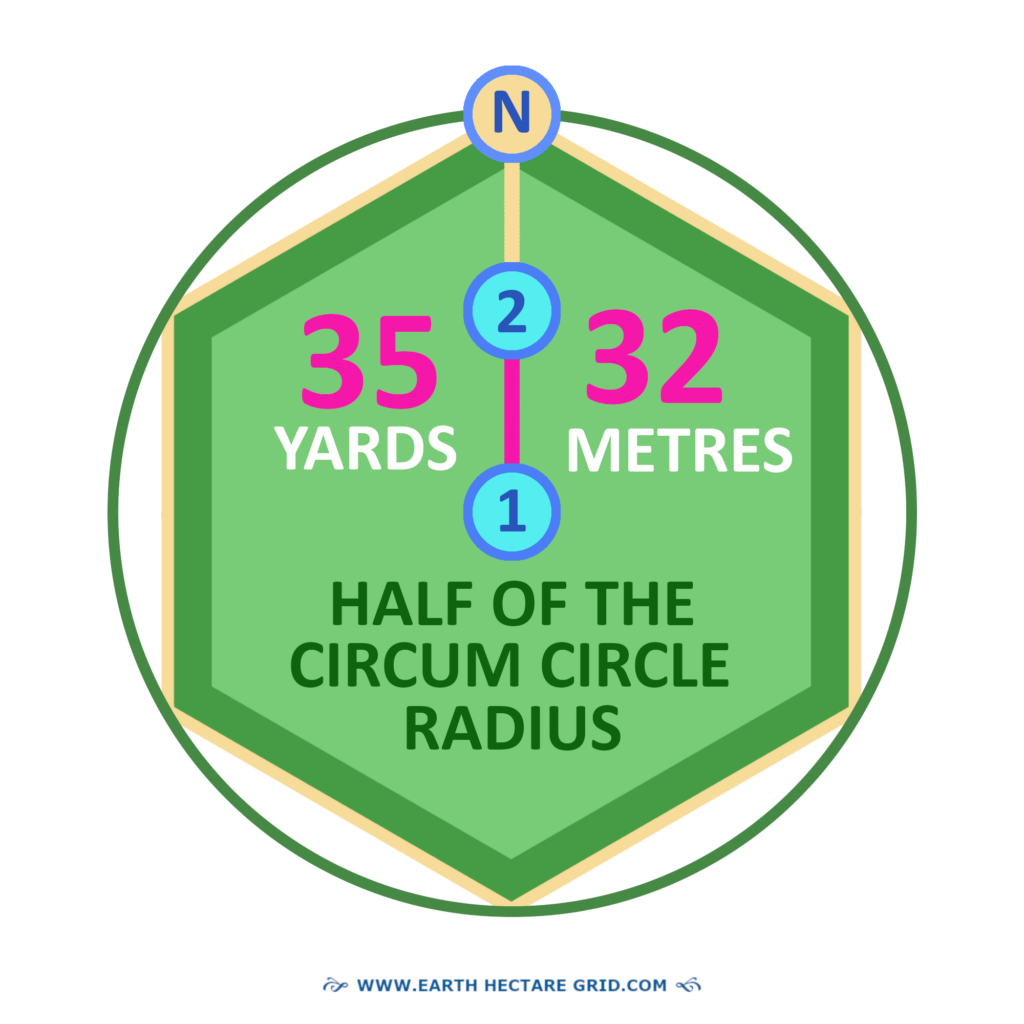
The outer boundaries of the hectare can also be derived from this middle circle. Therefore it is even better to start this way, because the middle circle contains all coördinates for the construction of the hectare. For this we need even a smaller size of cord! It is exactly half of the length of the Circum Circle Radius!
35 YARDS, 32 METRES
Half of the length of the Circum Circle Radius is 35 yards or 32 metres. With the length of this shorter line all the circles of the Flower of Life formation are made!
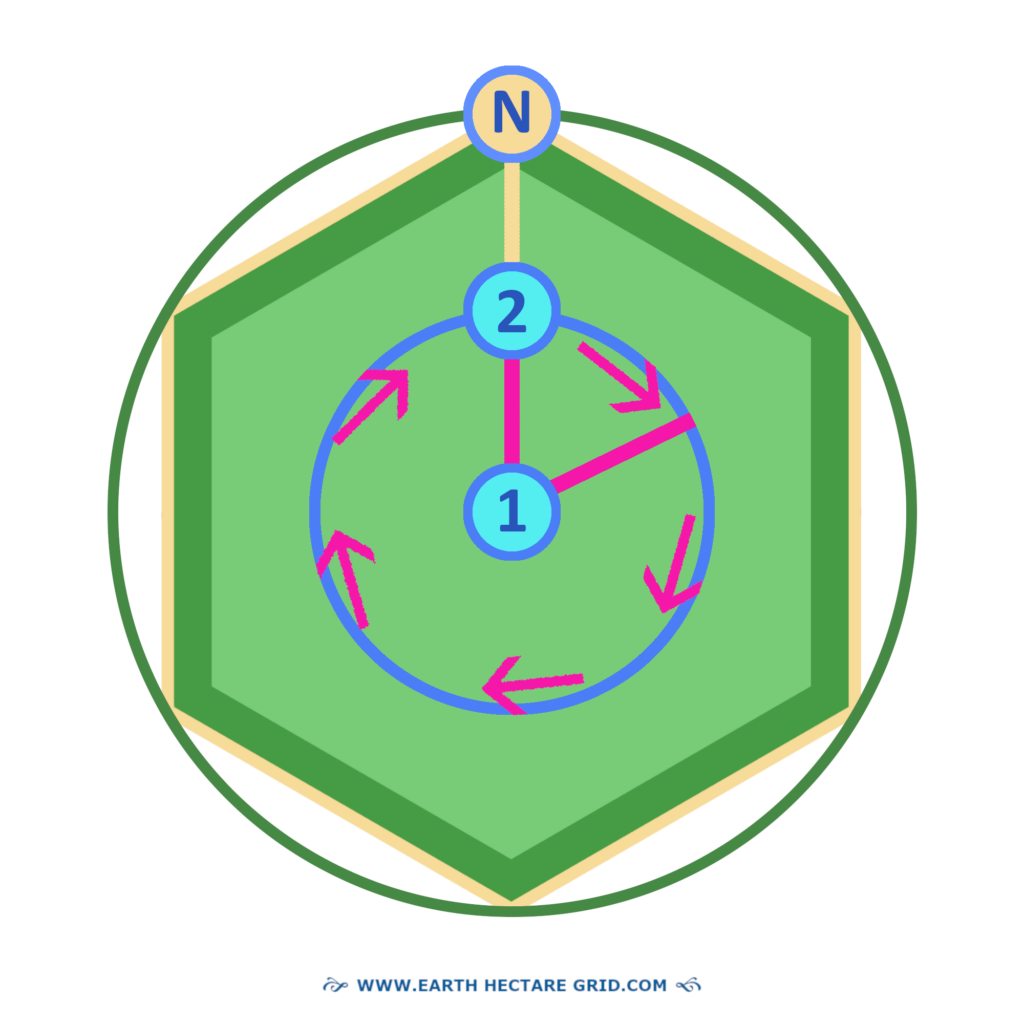
TURNING AROUND
By turning half of the length of the Circum Circle Radius around like the hands of a clock, one creates the actual circle (here it’s done clockwise, but the opposite direction is fine too).
DRAWING THE CIRCLES
Now we can draw the circles on the real ground!
We can either start with the vast
surrounding circle of the hectare,
or with the smaller middle circle
of the Flower of Life formation.
As the matter of fact,
this one is really so simple
that anyone can do it!
SIMPLE METHOD
The beginning of the cord is tied in the middle of the hectare, the middle of your 2.5 acres. How can one do that? Well, one can connect one end of the cord to a pole or tent peg. One can also use a chair or other objects.
When there are two people, one can keep the beginning of the cord in one’s hands. Then the other walks in a wide circumferential motion with the outer end of the cord over the Circum Circle!
HOLDING THE LINE
Ever thought you would be literally ‘holding the line’? Well it’s possible.
Make sure however that the cord remains taut in a tight line all the while when walking the circum circle. So the material of the cord should not have any elasticity.
Then, how are we going to draw the circle onto the ground?
MARKING THE GROUND
A small stick or branch can be tied to the end of the cord. One can hover the stick over the ground while walking the wide circum circle. It is important to keep the branch or stick in a vertical position!
Deviating a few inches or centimeters here and there is okay. But a quarter of a yard will definitly raise your neighbour’s eyebrows. So the more precise, the better!
While hovering over the ground with the stick one can drop a few pebbles or other material to temporarily mark te ground.
THE NORTH CIRCLE
From the middle of the hectare we drew de first circle of the Flower of Life formation. Now we’re going to draw number two, the North Circle.
The North point of the Middle Circle, now becomes the middle of the North Circle! This spot is called the ‘Mid-North’-point of the hectare field. It is the number 2 on the Middle Circle. It can be easily detected because the Circum Circle Radius line is already there.
THE MID-NORTH POINT

THE SOUTH CIRCLE
Next is the drawing of the 3th circle, the South Circle. There is also a Mid-South point in the hectare field, number 3. This one is also situated on the North-South diagonal.
PERFECT ALIGNMENT
Therefore the first three circles are important because they are aligned on the North-South diagonal. The circles that are drawn afterwards will therefore be in exactly the right place!

*******
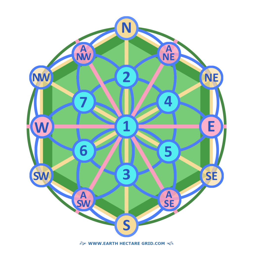
THE SEVEN BENCHMARKS
The systematic construction of the Flower of Life Formation creates six coordination points on its Middle Circle.
These arise because the seven circles overlap each other several times. This allows the entire hectare to be aligned. That is why these important points are also called benchmarks. They must overlap each other tightly!
OR ANCHOR POINTS
We can now draw four more circles. Their midpoints are all on the ring of the first circle in the middle. And they are important for construction of the hectare. Therefore we call them ‘benchmarks’. Or if one prefers, the term ‘anchor points’ can also enhance their meaning.
CHECK AND DUBBLE CHECK
How can one check if all the seven circles have been drawn correctly?
OVERLAPPING CIRCLES
The seven circles should overlap each other perfectly and thus have the same height and mirroring coördinates (as the Flower of Life formation is symmetrical).
THE OTHER TWO
The other two Long Diagonals should also be perfectly crossing the Seven Benchmarks on the Middle Ring and ending at the Outer Vertices!
THE SIX APOTHEM MIDPOINTS
Now there are six more coördination points! But these are on the outer sides of the hexagonal hectare en of lesser importance for the basic construction. They are the midpoints of every side.
They are created where the six outward circles of the Flower of Life formation overlap each other.
They are also called the ‘Apothem Midpoints’. But what is an Apothem?
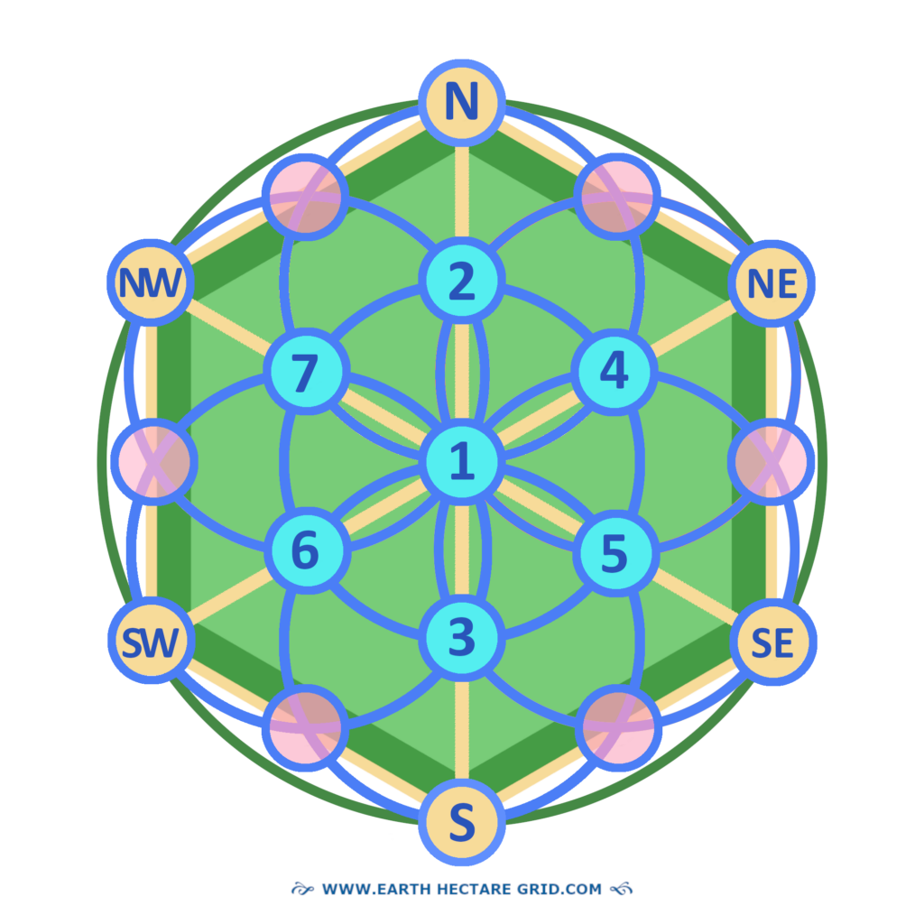
THE APOTHEM
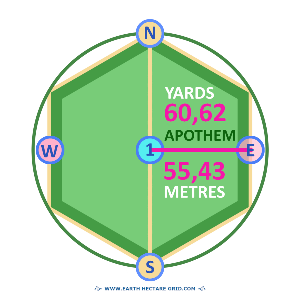
The Apothem is the official name of the distance or perpendicular from the center of a regular polygon to the midpoint of a side.
The word is derived from the Greek ‘Apothema’ which means ’the lowered’ or ’the distance from the center’.
For the uniform hectare size of
the Earth Hectare Grid the Apothem is
60,62 Yards or 55,43 Metres.
THE DOUBLE APOTHEM
The Double Apothem forms a line from East to West. It’s total length is: <=>
121,24 Yards or 110.86 Metres.
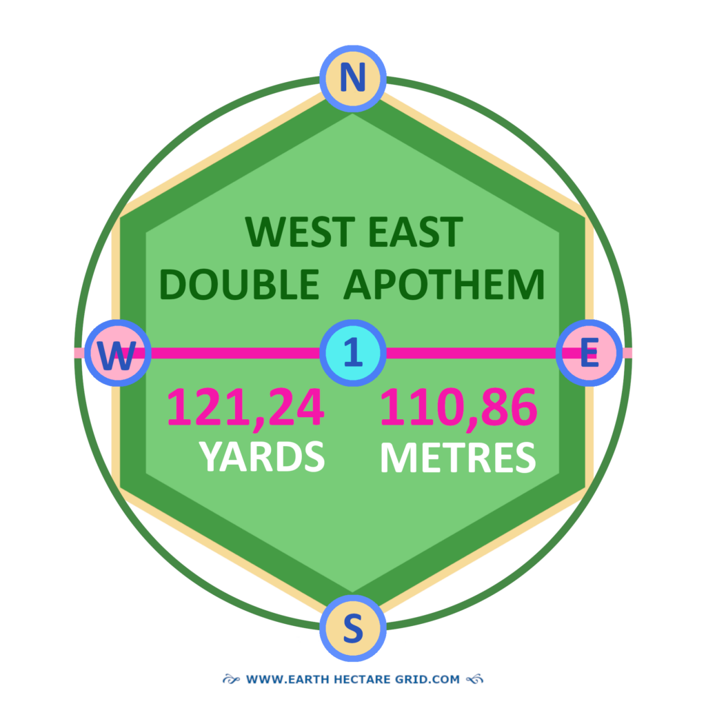
THE EAST WEST LINE
The East-West Double Apothem is not a Long or Short Diagonal. Therefore, we might want to use other words instead of ‘Double Apothem’ or ‘Diagonal’.
What could be the right terminology? Let’s name it ‘Line’ or ‘Direction’ for now!
THREE NEW LINES
As the Flower of Life is perfectly symmetrical, three new lines can be formed from the Apothem midpoints on all six sides to their opposite midpoints. As you can see, these form more specific (1/12th) geographic directions between North, East, South and West. The ‘A’ above the direction refers to the Apothem midpoints.
“Oost West, Thuis Best!” This is a Dutch expression!
THE UNIFORM HECTARE
Page is being updated. More text will follow.
UNIFORM DIMENSIONS
If you have come this far, you might also have an interest to view the map of the actual
UNIFIED HECTARE. This one has been designed with a grid on scale for the Metric system. The Empirical System is in the making!
It can be printed on an A4 size sheet of paper.
PRINT VERSION
An outline will be designed as well, so it won’t cost you all the ink of your printer cartridges…There is also an option to have it enlarged and print it in 4 parts.
When placed on window glass, so the light shines through, one can draw the lines over and over again on large sheets of paper and make sketches on them as much as one prefers!
ONLY TAKE WHAT YOU NEED
What if, at a given point in time there’s no more space on this planet for creating new Family Domains? It would not be possible to rearrange all the sizes of the already long term established Domains. Therefore, no-one should take more space than one needs. But with millions of Family Domains world wide, there’ll plenty for all of us. That’s it. Food for thought.
ON A SIDE NOTE
It should be noticed that the straight lines of the mathematical hexagonal shape might no longer be recognizeable on the actual plot. These will soon be overgrown by grass and crops, trees and forest.
And if you would incorporate wider and smaller curves in your design, by drawing circles around the corners of the hexagonal shape, and plant along those curvatures, a Flower of Life pattern might emerge, which gives the landscape more of a natural view.
MAXIMUM 1.3 HECTARE
1.3 hectares is the maximum size that a plot in a hectare village may have. This is only permitted due to unevenness or obstacles in the terrain. Think of the location along a canal, the shore of which must remain free. Or there is a start of a steep hill, and so on.

NORTH-SOUTH DETERMINATION
After drawing the circle it is important to determine the North. Because that’s where the first corner of the hexagonal hectare comes in. This is easy to do using a compass.
First, using the diagonal cord, we draw a line toward the North. And then, in extension, a line to the south.
THE ALIGNMENT
A fold-out vertical slot has also been created on some compasses. When you look through this, you can see a spot in the distance at the indicated point of the compass pointer. So if you have it aligned correctly, it points to the North. Then you can align the cord accordingly.
NEW BOUNDARIES
Compasses come with different functions and prices. You can buy one for around 3 euros, but also expensive ones for professional navigation. Thus the latter might add up to the previous mentioned 10 dollars of investment to actually aquire land and set up new boundaries.
WHERE IS NORTH?
But where exactly is North? A compass aligns with the magnetic north of our planet. It is located around the center of the North Pole. It is known however that magnetic north can fluctuate by hundreds of kilometers. So if hectares are built worldwide with the tip pointing to the magnetic North, this pattern will also fluctuate somewhat. Also, the magnetic north is is not the geographic North, which is based on the supposed rotational axis of our planet Earth.
EQUILUX
But there are also other methods. A better option might be to determine where the sun rises on the horizon. You can do that every day, but best would be at the time of the Equinox, during the spring or fall point. Then the sun is directly above the equator and day and night are the same length everywhere in the world. Thus we might also call it Equilux, for the day is lux = light.
On these two days of the year will the sun rise exactly in the east (with the exception of the landmass around the poles). Turned a quarter circle to the left from the point of sunrise, is North.
THE NORTH STAR
When one is in the Northern Hemisphere, it is also possible to determine North using the position of the North Star in the night sky. This star shines above the North Pole and is an estimated 433.8 light-years from Earth.
The star is recognizable in the constellation Ursa Minor (also known as the Little Dipper) at the end of a line. Together with Ursa Major it gives an image of two saucepans.
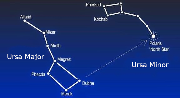
POLARIS
The North Star, also called Polaris, is aligned with the supposed rotational axis of our Earth. Therefore, from our position, it looks like all the other stars are orbiting Polaris.
DRAW THE LINE FROM ABOVE
When you have discovered Polaris, you imaginatively draw a vertical line from the star to the horizon. That’s the North Point!
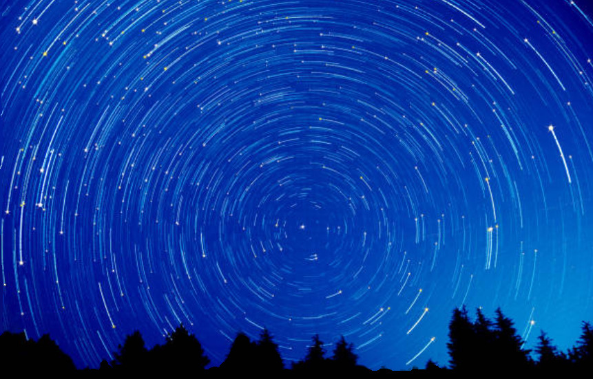
According to astronomers, Polaris’s position to the North will change at some point in the distant future, millions of years from now.
Then, they say, another star will take its place. It should be also noticed that the position of the Big Dipper stars surrounding Polaris do change during the year.
The picture below might be of help to recogize the constellation during the four seasons.

SIRIUS
You can also aim at magnetic north using a compass in the southern hemisphere, but this compass has to be adjusted for the southern hemisphere.
This is because the starry sky seen from the southern hemisphere also ‘rotates’ visually, but there is no significant star visible in the middle with which to align.
A number of stars do approach the southern point though, such as Sirius, but that has then to be observed in constellation with other stars as Sirius is not exactly in the middle of the rotating night sky.
*******
Next Page VILLAGE: HECTARE MAP
May Peace Be With Us
*******